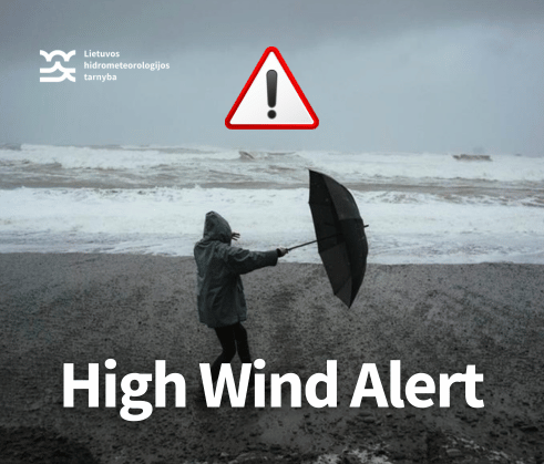
On the night from Sunday to Monday (10 PM–2 AM), southwesterly and westerly winds are expected to strengthen significantly. During the second half of the night and early Monday morning, wind gusts will reach 18–23 m/s across much of the country, 24–29 m/s in the southwestern regions, and up to 30–32 m/s along the coast. Winds are expected to begin easing in the afternoon.
Be cautious: secure or remove loose objects, close windows and doors, avoid parking near trees, and exercise care while driving or walking outdoors.
Year: 2024
18 October 2024 | Lithuania’s EuroCC2 Partners Strengthen HPC Collaboration
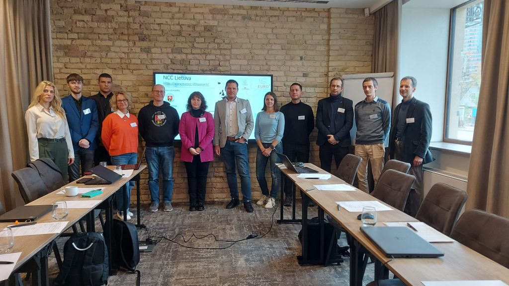
On the 15th of October 2024, the meeting of the partners of the EuroCC2 Lithuania project took place at the Calvary Hotel in Vilnius. The progress of the EuroCC2 project was discussed, experiences were exchanged, current and planned project activities were presented by the participants from the Faculties of Physics and Mathematics and Informatics of Vilnius University, Kaunas University of Technology Artificial Intelligence Centre, VILNIUS TECH – Vilnius Gediminas Technical University and Lithuanian Hydrometeorological Service. The main focus of the meeting was on the organisation of practical trainings and there was a discussion on the best practices of the partners in this field.
The strengthening of the co-operation between the project partners was the main focus of the discussions. Ideas were also exchanged on how to innovate and promote digital literacy in HPC in Lithuania. Discussions were held on identified needs for using HPC infrastructure in science, public administration, business and industry.
At the end of the event, the next steps for the achievement of the project goals were decided. The aim of the project is to strengthen the competences in High Performance Computing (HPC), High Performance Data Processing (HPDA) and Artificial Intelligence (AI) in Lithuania and to promote their use in the research, public and business sectors, and to foster peer collaboration.

14 October 2024 | Lithuanian Hydrometeorological Service delegation visits Norwegian Meteorological Institute
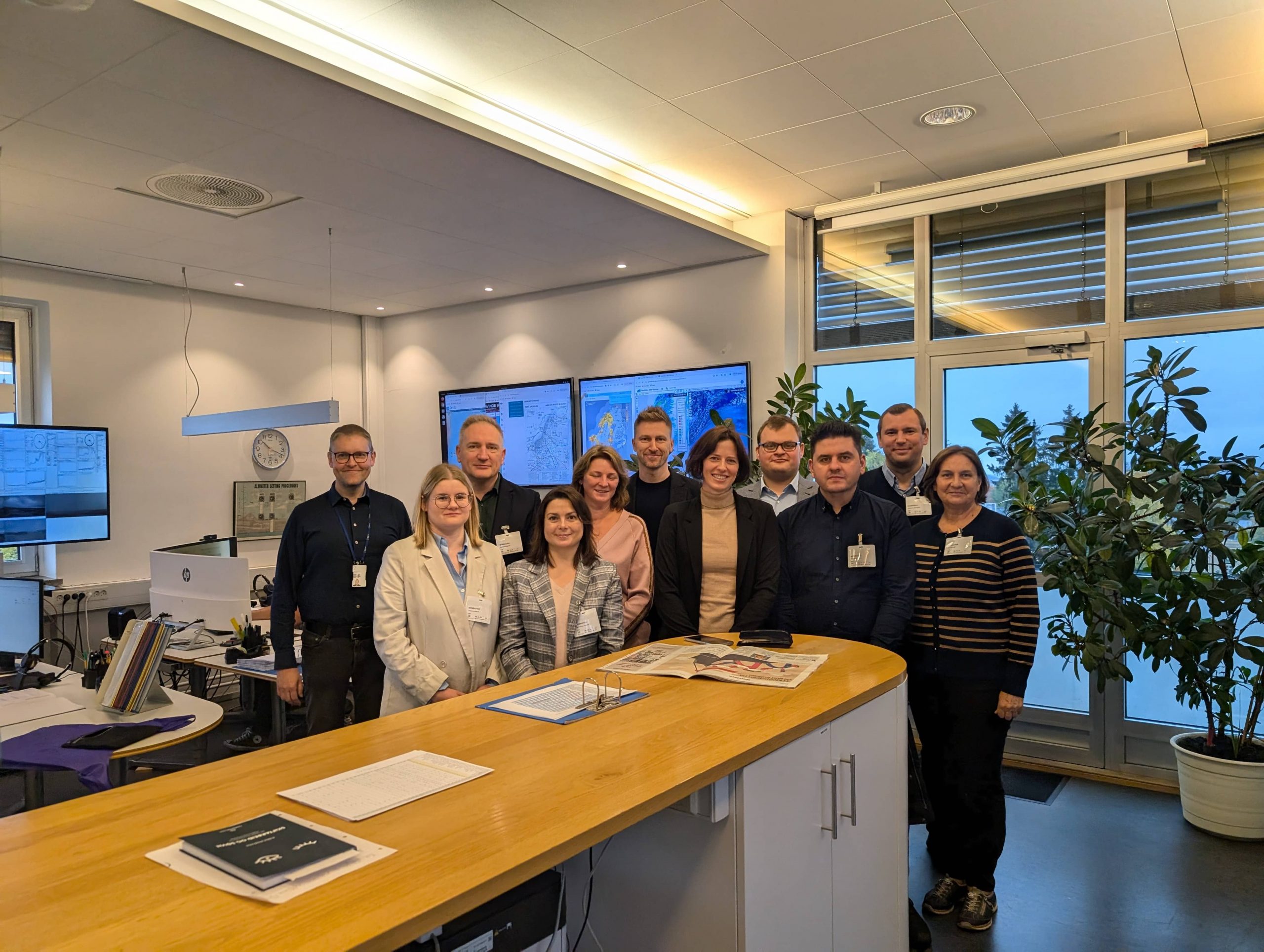
A delegation from the Lithuanian Hydrometeorological Service visited the Norwegian Meteorological Institute (MET Norway) as part of a project under the Nordic-Baltic Mobility Program for Public Administration. The visit aimed to strengthen international cooperation and facilitate the exchange of best practices between the two organisations.
During the visit, the delegation explored several key topics. One of the main areas of focus was the development of impact-based weather forecasting, aimed at improving the accuracy of warnings and raising public awareness of potential hazardous weather events.
Discussions also covered the potential for partnerships with other institutions to expand the meteorological observation network and ensure data quality, with particular attention given to integrating stations from third countries.
Another significant topic of discussion was the application of artificial intelligence and machine learning in meteorology. The delegation examined how these technologies could enhance the precision of hazardous weather predictions and improve data processing efficiency.

11 October 2024 | Australian Bureau of Meteorology Representative Visits the Lithuanian Hydrometeorological Service (LHMT)
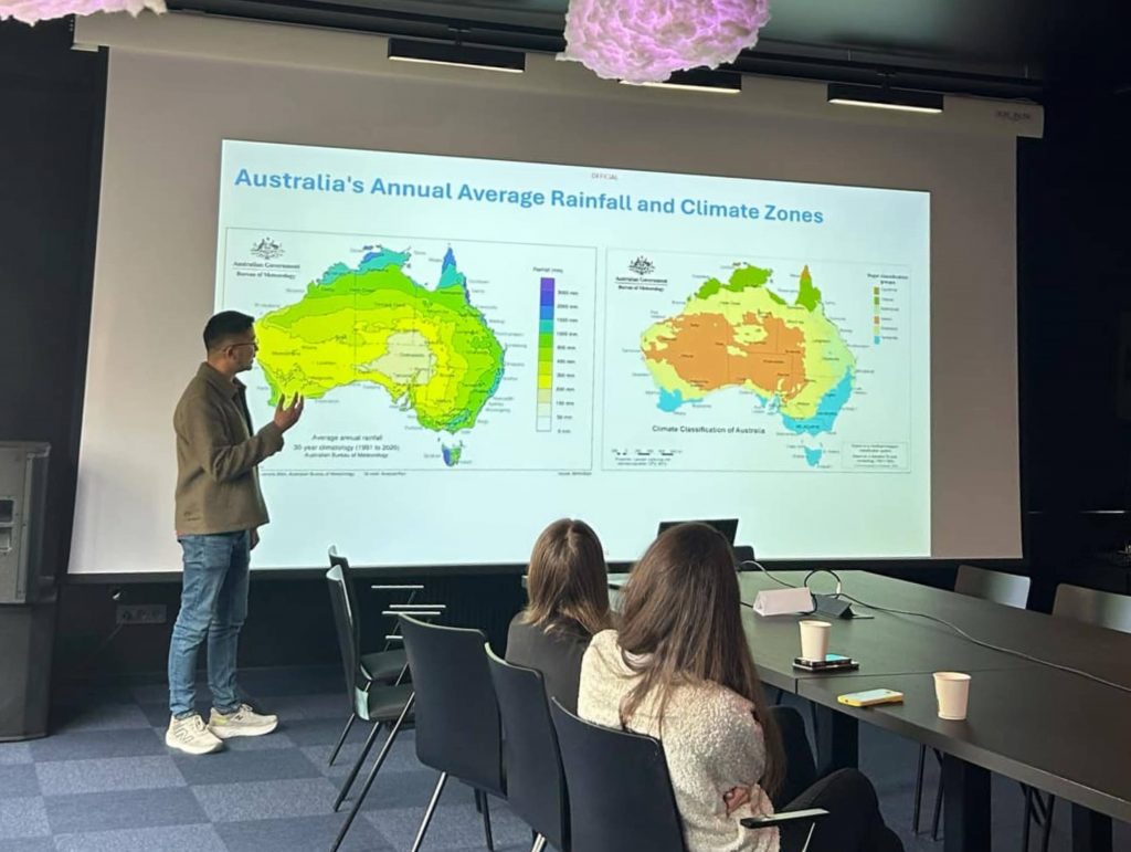
On October 10, the Lithuanian Hydrometeorological Service (LHMT) hosted a meeting with Jonathan How, Senior Meteorologist from the Bureau of Meteorology, Australia. During his visit, Jonathan shared valuable insights on Australia’s climate zones, the distribution of annual rainfall, and public communication strategies that help deliver meteorological information effectively to the public and decision-makers.
LHMT specialists also gave presentations, covering important topics such as forecasting, meteorological observations, and information dissemination. The discussions focused on the latest practices, challenges, and ways to improve the delivery of meteorological data to the public, ensuring more accurate forecasts.

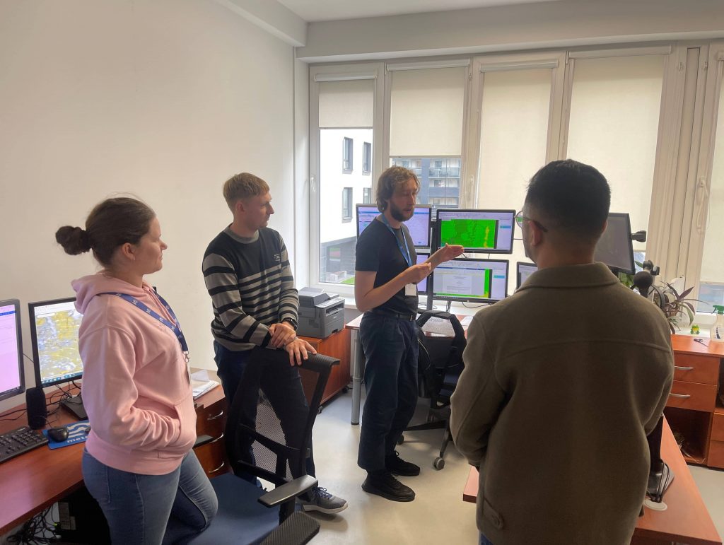
7 October 2024 | ICEREG Project Report
Project Overview
The management of ice jam flood risk in the Latvian and Lithuanian regions in the context of climate change (hereinafter referred to as ICEREG) is a cross-border project aimed at improving the management of ice jam flood risk in the border regions of Lithuania and Latvia. The main objective of the project is to develop comprehensive flood risk maps and improve the conceptual model of ice jam formation, taking into account the impact of climate change.
Ice jams pose a significant threat as they can cause large-scale flooding and inflict considerable damage on the environment and economy, particularly in border communities. Since the dynamics of ice jams have not been thoroughly studied to date, the ICEREG project seeks to analyze this phenomenon in greater detail, with special attention to the meteorological and hydrological conditions that lead to flood formation.
Research Overview and Results
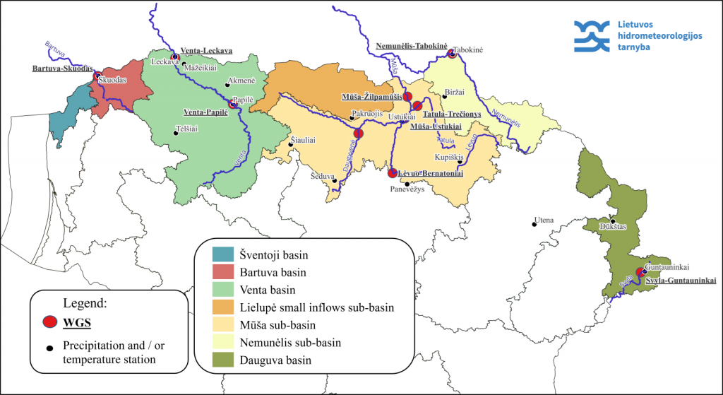
The project analyzed ice jam occurrences in rivers across northern Lithuania, focusing on 10 water measurement stations (WMS) located on the Bartuva, Venta, Mūša, Nemunėlis, Lėvuo, Tatula, Daugyvenė, and Svyla rivers. The analyzed period spanned from 1961 to 2023. During this time, a total of 237 ice jam events were recorded, with the highest number of events (50) at the Trečionys WMS and the lowest (1) at Žilpamūčiai WMS.
Impact and Damage of Ice Jams
Ice jams are particularly dangerous due to their unpredictability and the rapid rise in water levels they can cause. They form when larger ice floes get stuck on obstacles in the river, creating a temporary dam, which can quickly lead to natural disasters. Water levels rise above the jam and drop below, posing a significant threat to residents, infrastructure, and the environment.
Key Events
In the early 21st century, significant ice jam floods occurred in the Mūša and Lėvuo rivers. In 2010 and 2013, water levels in the Mūša River near Ustukiai exceeded critical levels by 90 cm and 125 cm, respectively. The April 2013 floods caused considerable damage in the Pasvalys district, where homes, gardens, and warehouses were flooded.
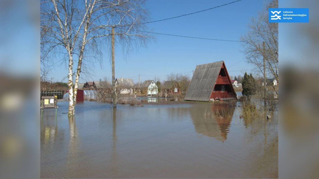
Similarly, in the Lėvuo River, significant water level increases due to ice jams occurred in 2010 and 2018, posing risks to nearby areas.
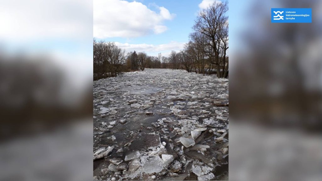
Conditions for Ice Jam Formation
Ice jams typically form when there is a sudden thaw after ice cover has developed in rivers, especially with significant temperature fluctuations between day and night. On average, ice jams start on January 10th at the observed WMS, and the ice jam period lasts about 8 days. The earliest recorded ice jam start date was October 30th (Tatula – Trečionys WMS, 1979), and the latest was April 14th (Mūša – Ustukiai WMS, 2013).
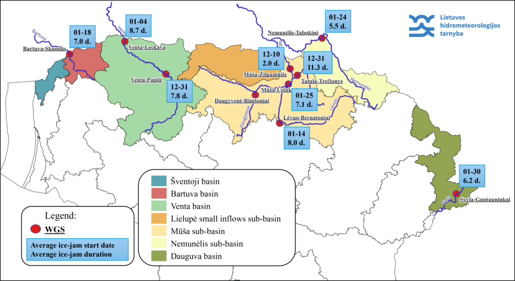
Pilot River Sections for Modeling
Two pilot river sections were selected for the project – Lėvuo (from Pamarliškiai to Skaistgiriai) and Mūša (from Gustoniai to Ustukiai). These sections were chosen due to their long observation periods and the significant impact ice jams are likely to have on the environment and residents. Based on historical data analysis, a conceptual model of ice jam formation and flooding is being developed, which will help assess changes in the primary parameters of ice jams based on climate change scenarios.
Conclusions and Next Steps
The ICEREG project is an important step towards improving the management of ice jam flood risks. The development of flood maps and the conceptual model will not only enhance the resilience of regions to flooding but also help create more effective early warning systems. The results of the project will be used not only for scientific purposes but also for practical flood prevention measures.
In the next phase of the project, detailed climate change scenario assessments will be conducted to better understand future ice jam dynamics and ensure that regions are prepared to face the challenges posed by a changing climate.
2024-10-01 | Lithuania had the warmest September in the history of instrumental measurements
This September was the warmest in the history of instrumental observations in Lithuania (i.e. the least since 1961, and in Vilnius since 1778)! The average monthly air temperature in Lithuania was 16.8 °C (or 4 degrees warmer than average). September of 2023 (16.5 °C) was in second place, while September 1975 (14.9 °C) was in third place.
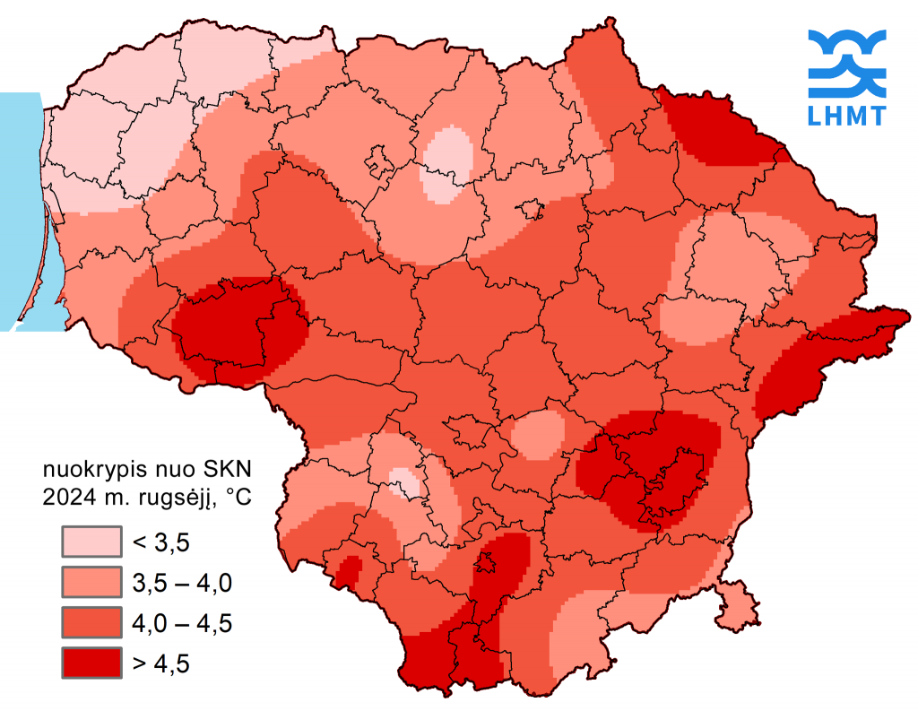
Both last year and this year, September saw no shortage of new heat records. In 2023, there were six daily maximum temperature records for the whole month, and this year there were seven more. There were also a few more days when the new record was very close to being broken.
The meteorological summer of 2023 ended late, as late as 4-5 October. And this year it ended a little earlier, on 28-29 September (or 3.5 weeks later than average). As a reminder, the average end of meteorological summer (1991-2020) is 4 September.
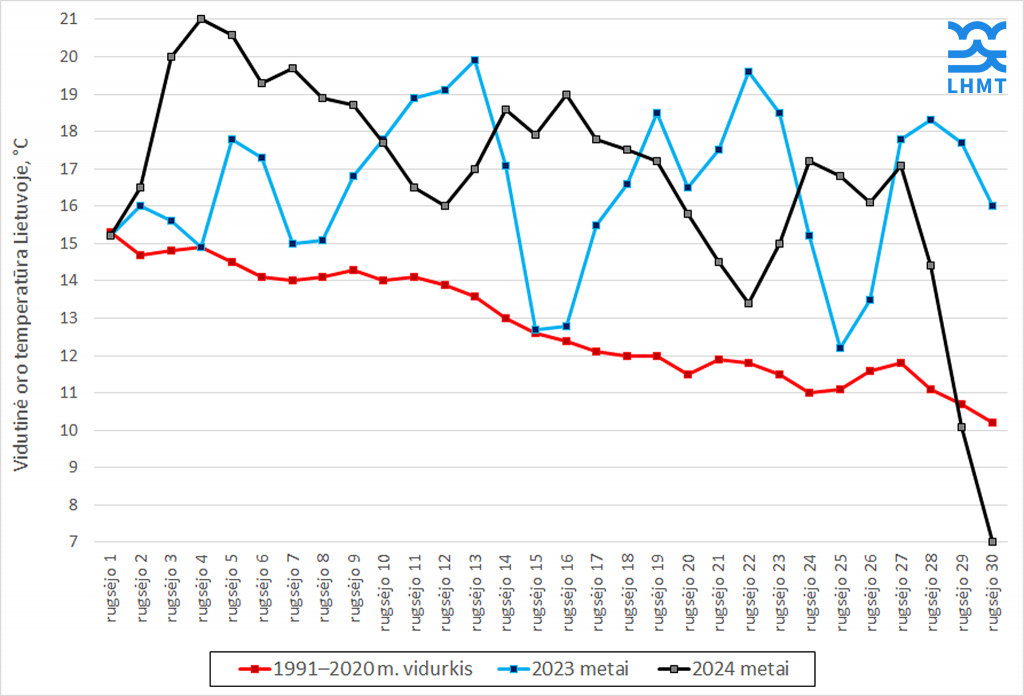
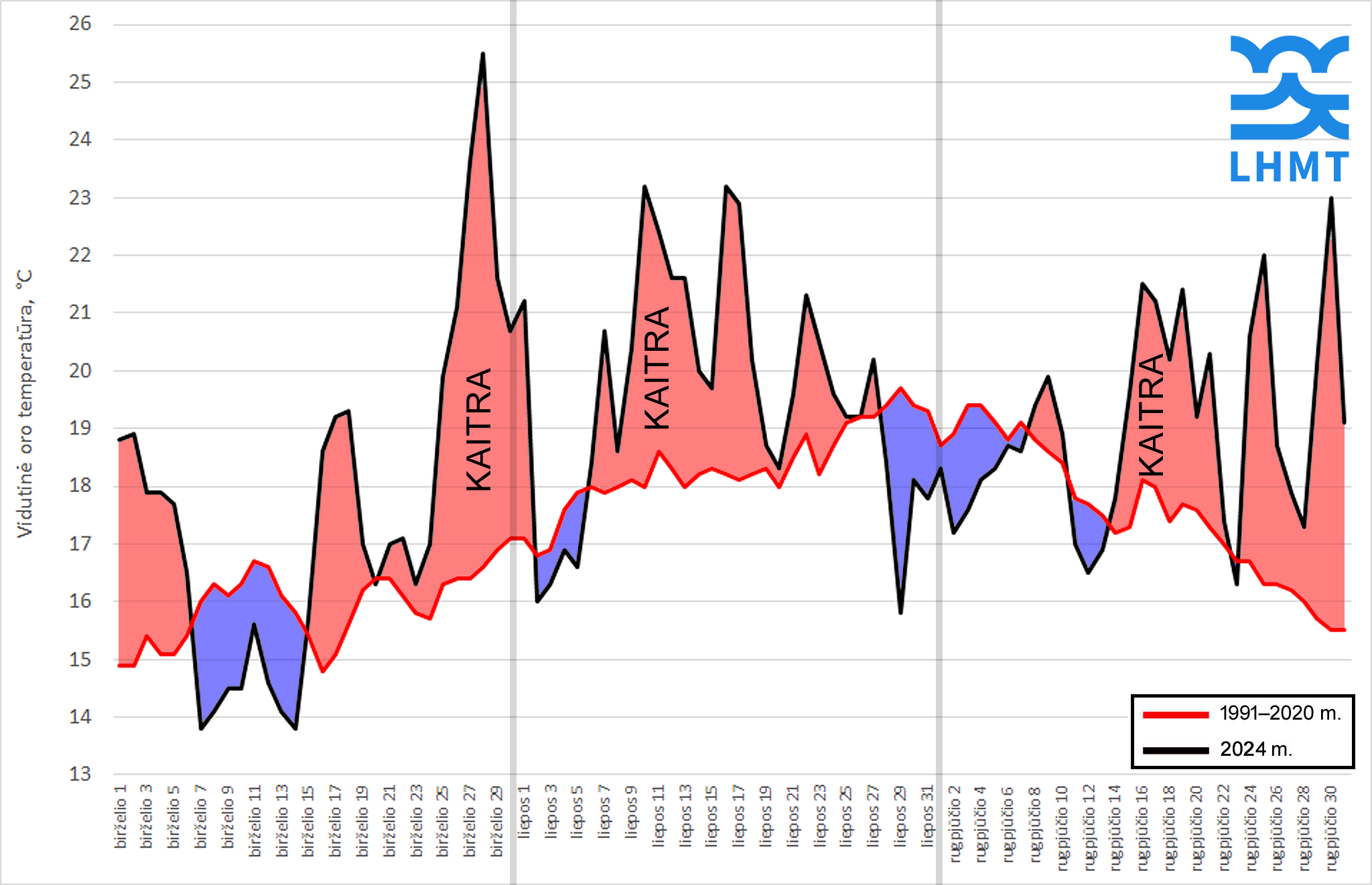
The graph shows the average air temperature in Lithuania for the period 1991-2020, in September 2023 and 2024. Note that almost all days in September 2023 and 2024 were warmer than the long-term average. Average daily air temperatures were often even in line with values for midsummer.
2024-09-19 | Where was the most lightning in May – August?
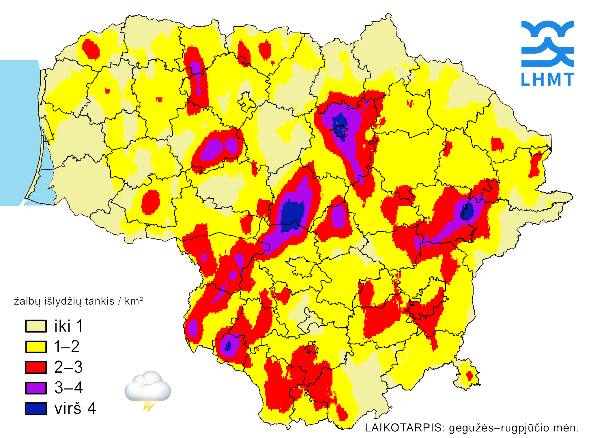
Map showing the density of recorded lightning discharges. The areas with the most lightning often coincide with areas where heavy rainfall, hail and wind gusts may have occurred.
In 4 months, out of 102,700 discharges, only 22,500 (~22%) hit the ground from the clouds. The rest of the discharges were between the clouds and did not reach the ground. The most frequent targets of lightning are overhead and underground power lines, bodies of water (lakes, rivers) and tall buildings (towers, wind turbines, etc.). The most dangerous are positive lightning discharges striking the ground from clouds. These are the ones that are most likely to strike people, grazing animals or wildlife fatally, and set forests, houses, etc. on fire. . The number of such discharges was very small – 4,517, or just 4.4% (about 1 in 23) of all recorded discharges.
The highest density of lightning discharges was recorded in the municipalities of Panevėžys Alytus, Kalvarija municipality. In Panevėžys, Kėdainiai, Šakiai and Molėtai districts there were >2.4 lightning discharges per 1 km². The least thunderstorms (i.e. the calmest) were in the seaside and coastal areas of Neringa municipality, Šilutė and Klaipėda districts and Palanga municipality (<0.8 lightning discharges/km²).

The total number of discharges in the period May-August was 102.7 thousand. The days with the most thunderstorms in this period were:
- 11 July – 14.7 thousand discharges;
- 13 July – 13 thousand discharges;
- 2 June – 10.1 thousand discharges;
- 25 May – 9.8 thousand discharges;
- 25 July – 5.1 thousand discharges;
- 29 May – 5 thousand discharges;
These six days alone account for just over half of the May-August lightning discharges. In 123 days (4 months), 41 days had no thunderstorms anywhere in the country, while another 25 days had only up to 20 discharges.
⚡️ There were 36.1 thousand lightning discharges in May;
⚡️ In June – 21.5 thousand;
⚡️ In July – 38.7 thousand;
⚡️ In August – 6.4 thousand.
Lightning detectors installed at meteorological stations in Lithuania (Biržai, Šilutė, Varėna and Raseiniai) record sky-to-ground lightning discharges and cloud-to-cloud discharges. Lightning detectors detect more than 90% of all lightning discharges within a 350 km radius. Thus, some thunderstorms go undetected (usually cloud-to-cloud discharges).
Prepared by LHMS meteorologist Gytis Valaika
2024-09-16 | International Day for the Protection of the Ozone Layer
16 September is International Day for the Protection of the Ozone Layer, to highlight the importance of the ozone layer for life on our planet. It is a good opportunity to take stock of progress and to remind us of the continuing need for action to protect this vital layer of the atmosphere.
This year’s slogan for the International Day for the Protection of the Ozone Layer is “Montreal Protocol: Advancing Climate Action” (Figure 1). The theme reflects the essential role of the Montreal Protocol not only in protecting the ozone layer, but also in advancing broader climate action initiatives worldwide. The success of this agreement inspires hope that other environmental solutions can also be achieved in a united way.

Figure 1 2024 slogan (https://ozone.unep.org/ozone-day/montreal-protocol-advancing-climate-action)
Ozone in the stratosphere acts as a natural shield, protecting the Earth from the sun’s harmful ultraviolet rays. This layer is essential not only for human health but also for the balance of ecosystems. Over the last few decades, thanks to the implementation of the Montreal Protocol and international efforts, significant progress has been made in reducing the use of ozone-depleting substances. However, challenges remain and international cooperation and the continued introduction of advanced scientific and technological solutions are essential.
The ozone layer over Lithuania has been continuously monitored since 1993 at the Kaunas Meteorological Station (MS). Until 2018, the observations were carried out manually using a filter ozonometer (M-124) (Fig. 2), and since 2018, ozone has been measured using an automatic spectrophotometer (Brewer MK III) (Fig. 3).
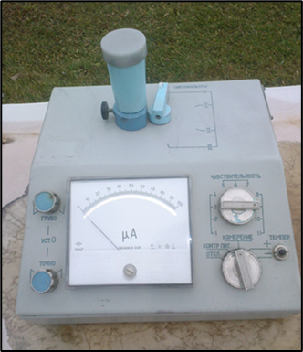
Figure 2 Kaunas MS used filter ozonometer (M-124)
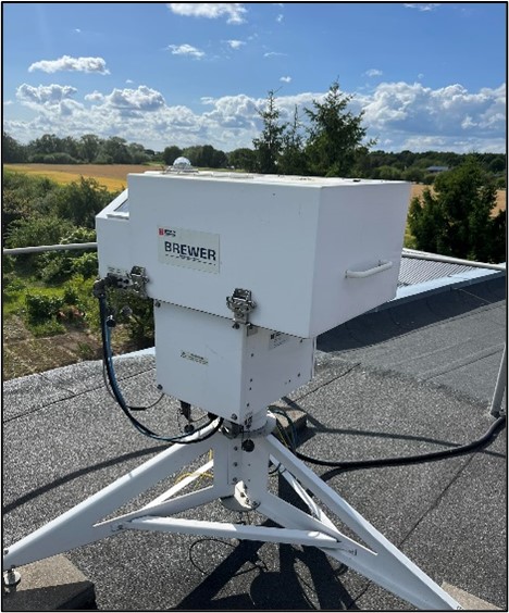
Figure 3 Automatic spectrophotometer (Brewer MK III) used in Kaunas MS
The data available from these instruments allow monitoring and analysis of the total ozone change (TOC) over Lithuania. Therefore, based on the available data, we present a brief overview of the GC O2 in Kaunas MS. The graph shows a pronounced seasonal variation of the TOC (Figure 4). The main causes of BOK variations over Lithuania are horizontal and vertical dynamical processes in the atmosphere, latitude and seasons.
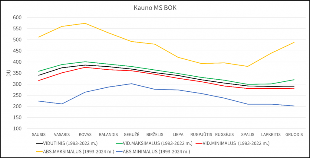
Figure 4. Ozone in Kaunas MS
The average TOC is highest in spring and summer, peaking in March (386 DU*).In summer (June-July), the TOC gradually decreases, with the lowest values observed in autumn (October-November) and winter (December).BOK peaks are most often recorded in spring, especially in March (574 DU, 03/03/2018), while lows are recorded in December (202 DU, 21/12/2007).This is because ozone (formed here or brought in from other latitudes) accumulates during the winter because it is less destructible due to the lower altitude of the Sun, and is more destructible during the summer when the altitude of the Sun is higher and the radiation is more intense.
World Ozone Day is an important reminder of our responsibility and our shared commitment to the health and sustainability of the planet.Only by working together can we ensure that the ozone layer continues to play its important role in protecting our tomorrow and our future.
Read more about ozone here.
You can read more about how each of us can do our part to protect the ozone layer here.
*1 DU – 1/1000 cm ozone layer under normal conditions – Dobson unit.
Prepared by Gintarė Giliūtė, Chief Specialist, Meteorological and Aviation Observations Division, LHMT
2024-09-09 | Was last summer very warm?
The average summer air temperature in 2024 was as high as 18.7 degrees Celsius (compared to a long-term average of 17.3 °C; in 2023 it was 18.1 °C, in 2022 18.5 °C and in 2021 19.2 °C). It was the fourth warmest summer in Lithuania in the history of modern meteorological observations (since 1961). Only 2021 (19.2 °C), 2010 (19.0 °C) and 2002 (18.8 °C) were warmer.
Translated with DeepL.com (free version)
This year, the average temperature in June was 17.6 °C (17.1 °C last year), in July 19.6 °C (17.6 °C last year) and in August 19.0 °C (19.5 °C last year). Although the calendar summer was very warm overall, the averages for individual months do not give a complete picture of the past summer. You can clearly see from the graph that each month had both cooler and very warm days (the latter predominating).
Translated with DeepL.com (free version)
Of the 92 days in the calendar summer, 63 were warmer than the long-term average: 21 warm days in June, 22 in July and 20 in August.
During the summer, 28 very hot days (compared to 17 last year) were observed, with daily average temperatures ≥20 °C. On average, the hottest days were 28 June (25.5 °C) and 27 June (23.6 °C).

The graph shows the average summer air temperature in Lithuania for the period 1991-2020 and 2024.
Three heatwaves were recorded during the summer (one last year): 26-28 June in Birštonas, Dotnuva, Šumsk and Varėno; 9-11 July in Marijampolė, Druskininkai and Kalvarija; 16-18 August in Alytus, Kalvarija, Lazdijai and Marijampolė. The highest air temperature this summer was measured on 11 July in Druskininkai, where the air heated up to 34.9 °C (see map below).
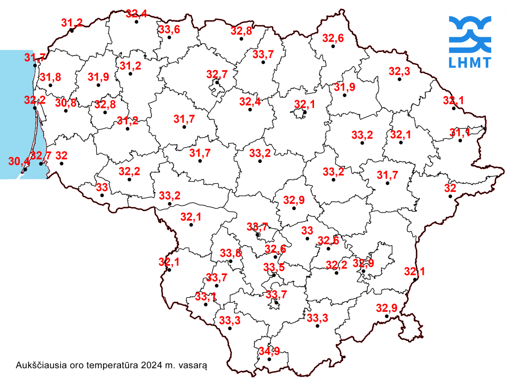
Map showing the highest air temperature in Lithuania in summer 2024.
Meanwhile, only 7 days were cool (8 last year), with daily average temperatures below 15 °C. The coldest days were in the first half of June.
In terms of rainfall, the summer rains were very uneven, both in terms of location and timing. Total summer rainfall in Lithuania was in line with the normal range of 225.9 mm (average for 1991-2020: 227.5 mm). Despite this, June (72% of normal) and August (49%) were dry months, while July was wet (168%; mainly due to a wind storm with heavy rain at the end of the month).
The duration of sunshine in the summer of 2024 was also in line with the norm, although it varied, as did rainfall. In Lithuania, the Sun shone for 819.3 hours, compared to a long-term average of 818 hours. In June, 103% of normal was reached, in July only 88% and in August as much as 110%.
You can read more about the summer months of 2024 here.
Prepared by LHMS meteorologist Gytis Valaika
2024-07-30 | On the extreme rain on 28-29 July
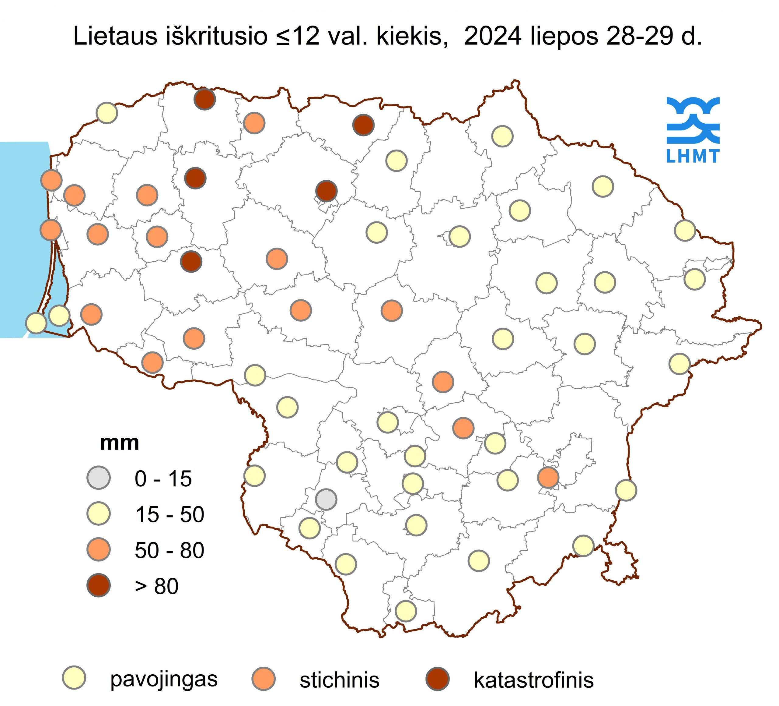
28-29 July It rained heavily in Lithuania. Very heavy rain fell at many stations of the Lithuanian Hydrometeorological Service (LHMS). Dangerous (15-49.9 mm, in ≤12 hours), severe (50-80 mm, in ≤12 hours) and catastrophic (>80 mm, in ≤12 hours) rains were recorded at all LHMS stations, except for Marijampolė AMS. The highest precipitation was recorded in Žemaitija and western part of Lithuania. Catastrophic rain was recorded at 5 meteorological stations: Telšiai (110.1 mm), Laukuva (97.3 mm), Šiauliai (93.1 mm), Joniškės (81.8 mm), Mažeikiai (80.7 mm). In 16 stations, cases of heavy rainfall were recorded.
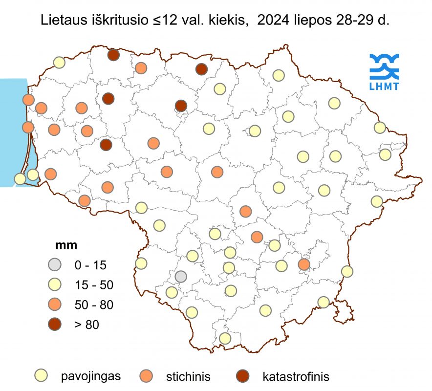
The highest rainfall in Telšiai in a ≤12-hour period to date was 90.7 mm (1984) and 81 mm (1970) in Laukuva. Meanwhile, no catastrophic rainfall has ever been recorded in Šiauliai, Mažeikiai.
Cases of more than 100 mm of rainfall in less than 12 hours are extremely rare. Only a few such cases have been recorded in Lithuania since 1961: in 1961 in Žindaičiai (109.5 mm), in 1963 in Skuodas (113 mm), in 1980 in Sartai (200 mm), in 1985 in Aunuvėnai (110.6 mm), in Kyburi (111.7 mm) and in Pakruojis (115 mm), and in 2013 in Eidukai (104.7 mm) and in Kartėnai (118.2 mm).
Prepared by the Climate and Research Division
