7 October 2024 | ICEREG Project Report
Project Overview
The management of ice jam flood risk in the Latvian and Lithuanian regions in the context of climate change (hereinafter referred to as ICEREG) is a cross-border project aimed at improving the management of ice jam flood risk in the border regions of Lithuania and Latvia. The main objective of the project is to develop comprehensive flood risk maps and improve the conceptual model of ice jam formation, taking into account the impact of climate change.
Ice jams pose a significant threat as they can cause large-scale flooding and inflict considerable damage on the environment and economy, particularly in border communities. Since the dynamics of ice jams have not been thoroughly studied to date, the ICEREG project seeks to analyze this phenomenon in greater detail, with special attention to the meteorological and hydrological conditions that lead to flood formation.
Research Overview and Results
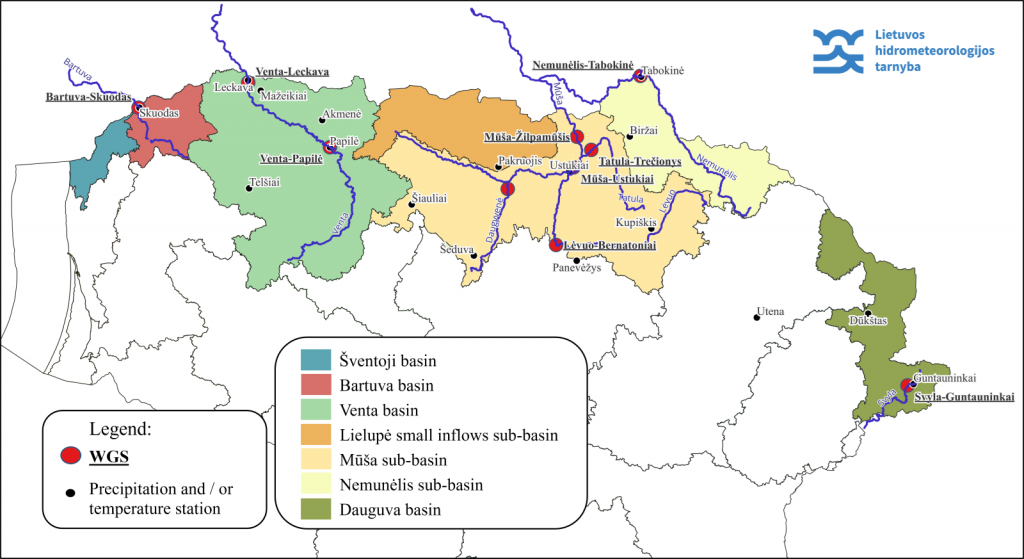
The project analyzed ice jam occurrences in rivers across northern Lithuania, focusing on 10 water measurement stations (WMS) located on the Bartuva, Venta, Mūša, Nemunėlis, Lėvuo, Tatula, Daugyvenė, and Svyla rivers. The analyzed period spanned from 1961 to 2023. During this time, a total of 237 ice jam events were recorded, with the highest number of events (50) at the Trečionys WMS and the lowest (1) at Žilpamūčiai WMS.
Impact and Damage of Ice Jams
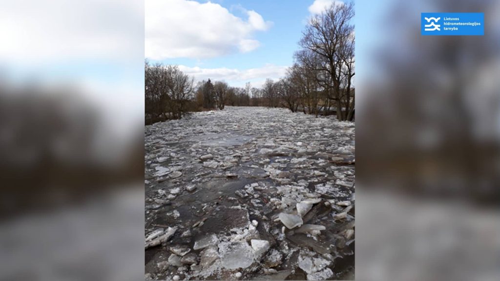
Ice jams are particularly dangerous due to their unpredictability and the rapid rise in water levels they can cause. They form when larger ice floes get stuck on obstacles in the river, creating a temporary dam, which can quickly lead to natural disasters. Water levels rise above the jam and drop below, posing a significant threat to residents, infrastructure, and the environment.
Key Events
In the early 21st century, significant ice jam floods occurred in the Mūša and Lėvuo rivers. In 2010 and 2013, water levels in the Mūša River near Ustukiai exceeded critical levels by 90 cm and 125 cm, respectively. The April 2013 floods caused considerable damage in the Pasvalys district, where homes, gardens, and warehouses were flooded.
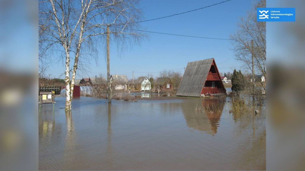
Similarly, in the Lėvuo River, significant water level increases due to ice jams occurred in 2010 and 2018, posing risks to nearby areas.
Conditions for Ice Jam Formation
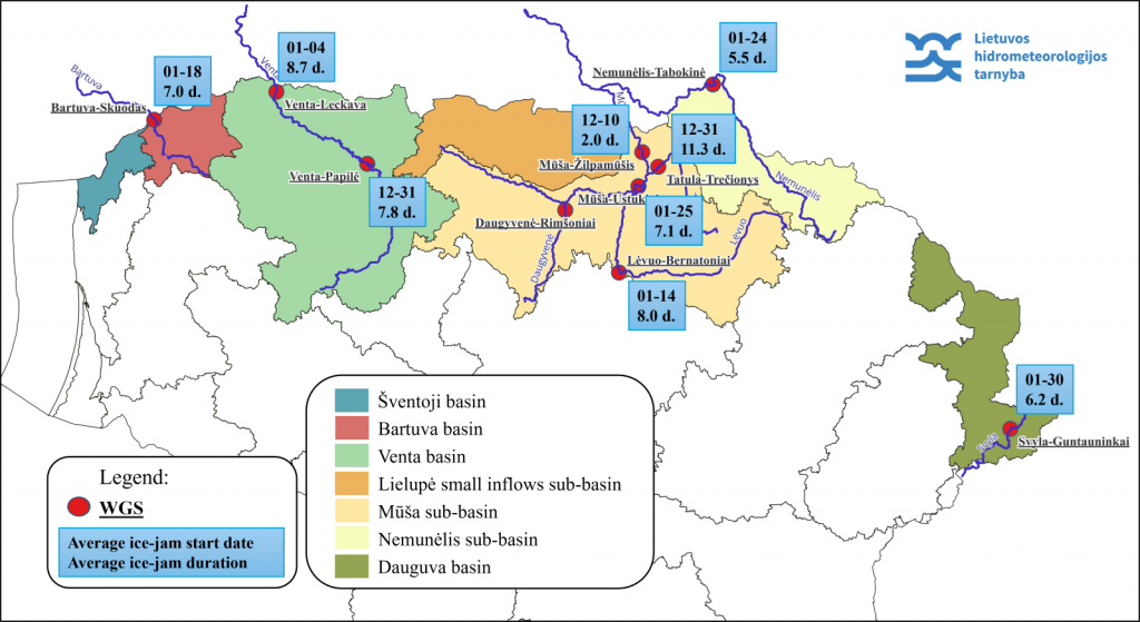
Ice jams typically form when there is a sudden thaw after ice cover has developed in rivers, especially with significant temperature fluctuations between day and night. On average, ice jams start on January 10th at the observed WMS, and the ice jam period lasts about 8 days. The earliest recorded ice jam start date was October 30th (Tatula – Trečionys WMS, 1979), and the latest was April 14th (Mūša – Ustukiai WMS, 2013).
Pilot River Sections for Modeling
Two pilot river sections were selected for the project – Lėvuo (from Pamarliškiai to Skaistgiriai) and Mūša (from Gustoniai to Ustukiai). These sections were chosen due to their long observation periods and the significant impact ice jams are likely to have on the environment and residents. Based on historical data analysis, a conceptual model of ice jam formation and flooding is being developed, which will help assess changes in the primary parameters of ice jams based on climate change scenarios.
Conclusions and Next Steps
The ICEREG project is an important step towards improving the management of ice jam flood risks. The development of flood maps and the conceptual model will not only enhance the resilience of regions to flooding but also help create more effective early warning systems. The results of the project will be used not only for scientific purposes but also for practical flood prevention measures.
In the next phase of the project, detailed climate change scenario assessments will be conducted to better understand future ice jam dynamics and ensure that regions are prepared to face the challenges posed by a changing climate.